One of the craziest experiences I had during my three months in New Zealand was definitely my first real alpine hiking experience. The Tongariro Alpine Crossing is located approximately 30 kilometers south of Lake Taupo, on the central plateau of the North Island. It is a volcanic area with several active volcanic sights such as steaming vents, volcanic rocks, and more noticeably, the two active volcanoes: Mt. Tongariro and Mt. Ngauruhoe.
The trail starts in the middle of nowhere, more specifically at the Mangatepopo car park, but since this 19.4 km one-day track is dubbed one of the best one day walks in the country by numerous guide books, it is frequented by several thousand people every day.
The tricky thing about this great walk however, is that it is not circular. This poses as a top tier business opportunity for the many shuttle buses that run daily tours from as far away as Taupo, around 100 km away. The way it works is that the shuttle drops you off at the Mangatepopo car park in the morning, and then waits for you on the other side, at the Ketetahi car park to pick you up in the afternoon. I had booked my shuttle for the 20th of January 2017 with the pickup time 6:00 AM.
Before I set out on my first alpine adventure, I had set the goal that I absolutely wanted to climb Mt. Ngauruhoe, no matter the weather. Mt. Ngauruhoe is to most people known as Mt. Doom, as it features as the infamous landmark of Mordor in the Lord of the Rings trilogy. In fact, a large part of the area around the Tongariro Alpine Crossing was used as backdrops for the landscape of Mordor, which as a total Tolkien fanboy made me very excited - I was simply going to walk in to Mordor and climb Mt. Doom. Because of the length of the trail however, I had to make some hard choices as to what I packed camera-wise. There is no means of refilling your water supply on the 19.4 km long track, so I decided to bring my only 50 mm lens, which freed up space in my bag for extra water.
I was picked up rather late (at least when it comes to Tongariro shuttle times) at 6:25 AM in the morning, and arrived at the car park at 7 AM. It was overcast with light rain, but that did not keep the masses from this popular walk. Hundreds and hundreds of people poured out of various buses, cars and campers, and I was rather disappointed to see so many people, as I thought the weather would make a lot of visitors stay at home. However, I decided to make the best of it, and started walking alongside what felt like half of all the tourists in New Zealand.


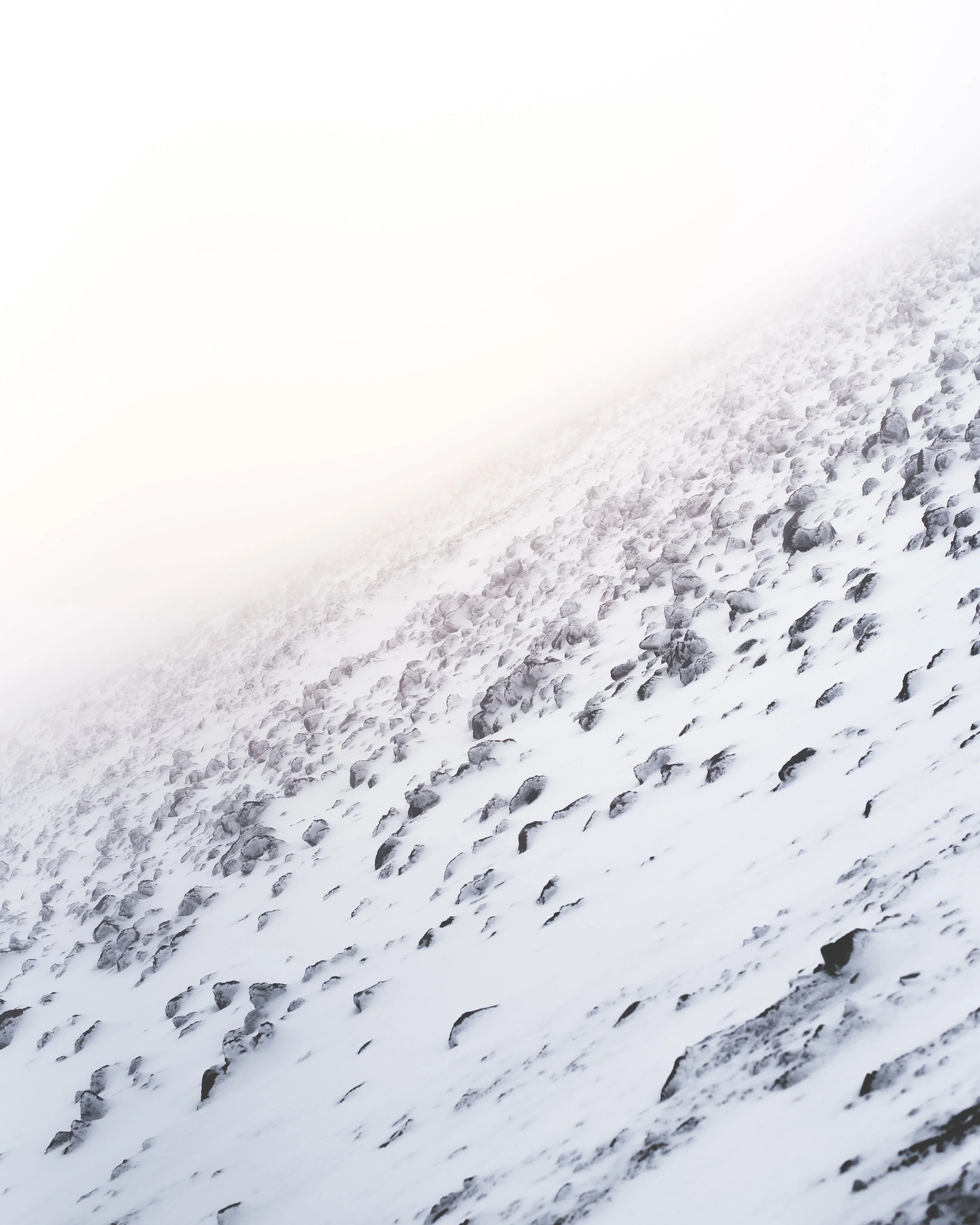
I quickly learned that my long legs proved advantageous, as I easily outpaced the worst of the 7 AM crowd, and as the elevation gained, the track became enshrouded in the clouds, and the rain turned into sleet. Within less than two hours I had made my way up to the base of Mt. Ngauruhoe, or at least that was what the signposting said. It was so foggy that I could barely see 5 meters ahead, and the temperature must have been well below zero at that point, as everything had been encased in ice and snow.


Determined as I was however, I was not going to let a little bit of snow and frost stop me from conquering the mountain. A lot of people were taking a well-deserved break at the base, but nobody even considered taking the climb because of the terrible conditions. One other guy, a Latvian with a huge backpack, was the only one considering climbing up, so we partnered up, and started walking towards the first of the blue poles indicating the track to the summit. At this point I was 1650 m above sea level, having already hiked up 500 meters of elevation from the car park which is 1120 m above sea level. The summit of Mt. Ngauruhoe is 2291 m above sea level, meaning I had 700 meters of elevation ahead of me.
Because of the dense fog and the ankle high snow, we lost track of the blue poles within literally 3 minutes. Soon after, the elevation really started to gain, and my climbing mate quickly fell behind because of the weight of his backpack. Many will tell you that climbing Mt. Ngauruhoe is no easy feat, as the slopes of the mountain is volcanic ash, and by its very nature is treacherous to walk on. One step at a time, I slowly made my way up. At first, I followed the footsteps of two other hikers that also decided to defy the weather, but I quickly overtook them too (thank God for long legs).
At this point, however far up the slopes of Mt. Doom that I may have been, I was pretty sure I was going to be the first of the day at the summit. I turned on my phone and put on the Lord of the Rings: Return of the King soundtrack and really got in the fanboy mood. The weather was in no way improving, but suddenly the steep ash slopes gave way to rocks with steaming vents in between, melting the snow. It was at that point I reconnected with the actual track, and 5 minutes and a little bit of rock climbing later, I found the little metal pole that marked the summit - I had made it, and I was all alone. Checking the time-stamp of my photos I can make out that the climb from the base of the mountain took me little over an hour - even though it felt like an eternity struggling up through the weather.

After taking a well-deserved 20-minute break, and eating some of my cherished Muesli Bars, it was time to head down again (remember, I had a shuttle bus to catch). Going down was much easier, and I could not help thinking how easy it would have been if I had brought a sled with me - sledding down Mt. Doom is definitely on my bucket list now. Clouds were still blocking the entire view, although you could sense the presence of a bleak sun above the clouds. Then, suddenly a hole in the clouds appeared, revealing how far up I actually was.

I will never forget this view. Sleet was slamming in my face and my fingers were frozen, but I quickly got my camera out and shot this 5-picture panorama. Being from the flat country of Denmark, I am not really used to heights, and somehow walking up the slopes in the mist made me forget that I was actually walking up a mountain - I just looked down and mustered my strength to keep going. To have this view unfold and actually realize that I had just climbed a massive (active) volcano left me speechless - not that I had anybody to talk to anyway.
The rest of the walk was pretty dull compared to my experience on the slopes of Mt. Doom, so I will not go into detail about that. In total I walked 30 km with the elevation spanning from 700 m to 2300 m, in a total of 9½ hours, and even though I thought to myself that I would never do it again, I actually came back two months later, but that is a story for another time.